The model contain four ameba-shaped patterns with +_8% of velocity anomalies with respect to the 1D velocity model which is presumed to be known exactly (file "refmod.dat"). The anomalies remain unchanged at all depths. The locations of sources provided in file "rays.dat" are not exact: they are computed based on source locations in the 1D velocity model. They are obviously strongly biased with respect to true locations due to strong lateral heterogeneities. Configuration of the model, data setup and inversion results obtained using LOTOS-07 code are shown in Figure 1:
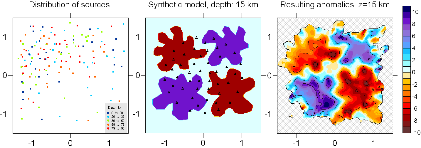
Figure 1. Setup of Model 1 and reconstruction using the LOTOS-07 code. Left: distribution of events (true values). Middle: configuration of synthetic model (anomalies are given in percents with respect to the 1D velocity model). Black triangles show the stations. Right: Reconstruction results using the LOTOS-07 code. Dotted and solid contour lines corresponds to amplitudes +_4% and 8%, respectively.
The data for this test can be downloaded using this link: "download inidata.zip" .
The data setup for this test has been produced artificially. The area of the station distribution is roughly isometric and is of ~200 km size. For each of 148 events the number of recorded P picks varies randomly from 25 to 50. For 40%-80% of the recorded P picks we create the S picks. In total, for each dataset, we have produced 8764 pairs of source/receivers corresponding to 5522 P and 3242 S phases. The travel times for this test have been computed using 3D ray tracing (our own version of bending method) through ameba-shaped anomalies of +_ 8%. Then the coordinates and origin times of the sources have been "forgotten". The "true" 1D velocity model is presumed to be known. Here we present the dataset with approximate locations of sources estimated using the "true" 1D model. The location of sources is performed using the initial steps of LOTOS-07 code.
The "inidata.zip" includes three files:
1. "rays.dat" file which contains travel times and approximate source coordinates located in the 1D reference model "refmod.dat" (also approximate).
First line is a description of an event which includes geographical coordinates: longitude (degree, W-negative), latitude (degrees, S-negative) and depth (km), and number of recorded phases, NPhase.
After the line of source description, NPhase lines follow.
First column is phase indicator (1:P, 2:S), second column is number of
station according to the list in "stat_ft.dat". Third column is travel time, in
second. Below is example for one events from "rays.dat":
-1.295288
0.8543872
46.00000
57
1 32
30.48650
2 32
52.48297
1 30
21.47959
2 30
36.35460
1 34
31.34636
2 34
53.34582
1 3
20.27702
2 3
35.07458
1 1
11.83463
2 1
20.21049
1 22
37.07683
2 22
63.51566
1 24
33.54958
2 24
57.27033
1 4
26.72274
2 4
45.58563
1 28
17.28950
2 28
29.48344
1 9
43.07382
2 9
73.04951
1 45
38.37197
2 45
64.71861
1 14
27.66569
2 14
46.65614
1 44
28.37934
2 44
48.25061
1 37
22.04670
2 37
37.39499
1 15
23.16819
2 15
38.91614
1 38
25.03835
2 38
42.48395
1 16
18.43762
2 16
31.35737
1 21
33.55720
2 21
57.48094
1 12
36.11247
2 12
61.45414
1 10
42.46933
2 10
72.05245
1 29
16.14342
2 29
27.48008
1 50
13.74259
2 50
23.10683
1 46
37.11286
1 33
34.06855
1 36
24.12580
1 42
16.39541
1 11
39.87333
1 47
31.87875
1 5
31.44924
1 6
35.09440
1 17
13.50717
1 23
36.48567
1 48
23.52219
1 35
27.84750
1 7
38.11598
2. "stat_ft.dat" is a file with station
geographical coordinates which includes longitude, latitude and elevation which
is given in km. Positive value means that the station is below sea level. In the
presented synthetic dataset, all the stations are at 1 km depth below sea
level.
-0.7642902
0.6408060 1.000000
-0.5177832
0.8476954 1.000000
-0.1744345
0.9797521 1.000000
0.2701586
0.9577430 1.000000
0.5826951
0.8080777 1.000000
0.8159962
0.5835809 1.000000
0.9656604
0.2930546 1.000000
1.005278 -5.9098393E-02
1.000000
0.8952304
-0.4332605 1.000000
0.6927426
-0.7061793 1.000000
0.3934121
-0.8954611 1.000000